FEW issues in agriculture push more people’s buttons than government regulation of land management practices. Coming up with a one-size-fits-all approach that manages to serve most of the interests most of the time, is like finding the Holy Grail.
In August 2017, the new NSW native vegetation legislation codes commenced in an attempt to do just that. In August this year, a review of those changes will be undertaken to test the effect of their implementation.
The state government sees this as an opportunity to fine-tune the new native vegetation codes, described by one government website as providing landholders “with more choices to better manage native vegetation on their property”.
For some farmers, the changes have done just that and are working as intended. For others, however, the codes have enshrined what they see as unwieldy, impractical and, in some cases, obstructive requirements that are resulting in worse biodiversity and environmental outcomes, with limited recourse for farmers to challenge the rules.
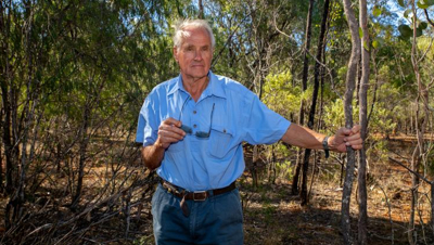
“We are treated exactly the same as the person who has knocked down every single tree on their place,” farmer Rob Anderson from Moree, North West NSW, says of the native vegetation legislation.
“There is no latitude for the good land managers over the bad. We are all treated as bad, and that sticks in my craw.”
There has been a long-held animosity and mistrust between farmers and government land management bodies. It’s into this climate that the Sustainable Land Management Office, a newly established unit in
Local Land Services (LLS), finds itself trying to rebuild reputations and relationships.
Failure to do so is likely to be detrimental to the success of the new codes, as the reforms are built on an assumption that farmers can – and, more importantly, will – work closely with LLS officers around the kitchen table to develop tailored native vegetation plans for individual properties.
But David Witherdin, chief executive officer of the LLS, is determined to make it work. “Our role is not in terms of compliance in relation to the codes – that sits with the
Office of Environment and Heritage [OEH],” he says. “Our focus is about enabling access to the new codes and ensuring they deliver the right outcomes.”
“Trust is something earned over time and is absolutely the key to the success of this. Give us the opportunity before you judge us. We are as keen as farmers are to make this work.”
David Witherdin, chief executive officer, LLS
David says it is a major reform process and a key initiative of the government in the agriculture space. “You don’t get reforms of this scale very often, so it’s a matter of working together to ensure there is success.”
But farmers including Rob Anderson – a member of the NSW Farmers’ Native Vegetation Working Group, along with Bronwyn Petrie, who is from Tenterfield in the Northern Tablelands – are concerned about key features of the reforms.
Bronwyn, a NSW Farmers’ executive councillor and member of the Conservation and Resource Management Committee, says the only way forward is to bring in amendments as part of this year’s 12-month review process.
She nominates her main concerns with the 2017 reforms as the new rules which require farmers to save a certain stem number of invasive native species per hectare; preventing the use of the new codes on land above 18 degrees, classified as ‘vulnerable land’; increased ratios for biodiversity offsets; and the new requirement for offsets to be set aside in perpetuity.
THE CONTROVERSIAL MAP
What is most concerning, Bronwyn says, is the government’s planned use of satellite mapping to delineate areas of regulated and unregulated ground across farming properties.
The Native Vegetation Regulatory (NVR) Map is prepared by the OEH, and is intended to cover all rural land in NSW and, according to the department’s website, “categorises land into areas where clearing of native vegetation can occur without approval, where clearing can only be carried out in accordance with Part 5A of The Local Land Services Act or other legislation, and excluded land where The Local Land Services Act does not apply”.
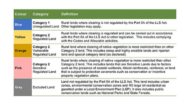 Each category of the map has been developed using a combination of scientific assessment and the application of data as specified in the legislation. Source: NSW Government OEH
Information about obtaining a Category Explanation Report and the Landholder Initiated Map Review process is available from the
OEH Map Review webpage or by contacting the Map Review Team: 02 6360 9000 or
[email protected]
It was slated to come into full effect in early 2018 but has been delayed, pending government consideration and approval.
The intention had been for that map to be definitive, meaning that, if brought into effect, farmers would have to abide by what the technology deems to be regulated ground. However, concerns have been raised that the technology does not work, as farmers have been reporting significant errors in the mapped areas.
“With the sample maps produced so far, our members have found so many inaccuracies in them that the Minister [Niall Blair, Minister for Primary Industries] has said they will not be used until they are right.”
Bronwyn Petrie, Tenterfield farmer and executive councillor, NSW Farmers
“The proposal is that farmers have a six-month window to have any errors changed, after which time they have to pay for changes,” Bronwyn says. “Farmers should not have to pay for government error, and six months is not long enough [for the NSW government] to get around all the farmers.”
Rob Anderson has been given a copy of the map for his mixed farming operation, as part of a NSW Farmers sample mapping project. “The boundaries on the map are not actually where they are, they’re 80 metres the wrong side in some cases,” he says.
“The boundary fence is on the wrong side of the creek but they said the only way to change that would be to re-survey the creek, and that would cost about $70,000 or $80,000.” He says the mapping errors are not confined to his property. “I’ve seen one that has a water course on top of a hill [where none exists]. And the top of that hill is therefore classified as environmentally sensitive. What happens if those maps become law?”
Part of the issue is identifying what constitutes regulated land. Rob says his map shows 24.6% of the property is regulated land. “I fine-tooth-combed it and came out with just under 18%. But you can’t query anything because they won’t answer.”
He says he is concerned that the vegetation management law has been passed – and passed based on it being reliant on the mapping – when the technology wasn’t yet proven.
A spokesperson for the OEH tells The Farmer the NVR Map identifying the sensitive and vulnerable land layers has been available since last year.
There have already been amendments to the map plans. In November 2017, NSW Minister for Primary Industries Niall Blair confirmed the mapping system would not be used in native grassland dominant areas, ostensibly around the Monaro region. Here, huge tracts of the exotic weed African lovegrass had been mapped as regulated land. Instead the government is putting $375,000 towards a joint effort of Monaro farmers and the LLS to develop appropriate land management practices without the use of the maps.
Adair Garemyn, NSW Farmers’ policy director – environment, says the Association fought hard for regional vegetation planning, rather than the state-wide approach that exists now.
She says the number of codes processed – effectively agreements from farmers around land management signed off by the LLS – and the areas where they are being processed, might be a good indicator of how well the whole system is working.
Fewer codes processed suggests less interaction with the LLS, and not enough appropriate codes for farmers to use in order to strike a viable balance between agricultural production and environmental management needs.
INVASIVE NATIVE SPECIES
Tony Vereyken, who inherited a small farm from his parents near Werris Creek in North West NSW, acknowledges that a one-size-fits-all approach to regulation is problematic, but says the new codes have worked “exceptionally well” in his case.
He didn’t know that the government’s vegetation map existed, and has separately had LLS officers out to survey his property from the ground. Like many farmers in the region, Tony battles the spread of cypress pine, which is considered an invasive native species. He says the previous rules meant he wasn’t allowed to touch anything and had to leave every tree that was there.
“I’ve got plenty of [non-invasive] box trees, but then there are these trees like the cypress pine and the wild olive that are a proper nuisance. If you had that many Bathurst burrs on your place, you’d get a summons to clean them up.”
Tony Vereyken, Werris Creek farmer
Tony said LLS officers worked with him to confirm plans to reduce those trees and renewed existing permits for clearing. “I think the whole problem is people are reticent to get these guys [the LLS] out. I was of the same mind but I could see I was in a losing battle with the pines. I don’t want to fall foul of the vegetation laws so I got them out. They were very polite and couldn’t have been more helpful.”
Andrew Hynes is fighting the same battle at his property west of Tenterfield and says that, while he is yet to finalise a permit to clear pine, he is confident about working with the LLS to get it organised.
The problem for him, and for others like Bronwyn Petrie, is the new rule that for every hectare cleared of an invasive native species, 20 stems need to be retained, while clearing is limited to 90% of any 1,000ha treatment area.
“We’ve got 150 head of cattle; we’d easily be running that many again if we didn’t have cypress pine. It’s been building up for years.”
Andrew Hynes, Tenterfield farmer
“Our carrying capacity is screwed… It’s been building up for years,” Andrew says. “When my grandfather was here he ran 10,000 sheep, now we’d be flat out running 3,000.”
Most farmers agree that leaving any invasive native species is a waste of their time because it perpetuates the work. “It regenerates, you’re making more trouble for yourself,” Andrew says.
“The next generation looks at that and says, ‘why would you want to come back to farming when you’re up against bureaucracy that works like that?’ It’s like leaving 20 Bathurst burrs. It’s ridiculous.”
It’s a sentiment echoed by Rob Anderson: “The LLS themselves are not the problem. They are good. It is the parameters they have been given to work within that are the problem.”
THE STRICT OFFSET SCHEME
One of those parameters is the strict offset scheme under the Biodiversity Conservation law. Traditionally, landholders have been given government permission to clear areas if they set aside other areas on their property of equal biodiversity value.
The problem, some farmers say, is that the ratio has been increased so more land must be set aside than ever before. Critically, where it could once have been set aside for 25 years, that has changed to in perpetuity.
Rob says he knows of a farmer in the North West who applied to clear 40ha and was told he had to offset, in perpetuity, 240ha.
“You have to manage it to their specification, look after the weeds, control the feral animals, pay the rates, preserve its biodiversity value – and not only you, but your grandkids, and if you sell the place the next owners have to do it, too,” Rob says. “So it becomes not only nil-value land, but a cost. That is a real issue.”
He says he needs permits and set-asides even if he wants to clear fence lines “to the drop distance of a tree”, or to clear space around his sheds to allow the road trains that service his property to load up and drive out. “It comes back to the fact you can’t get personal exceptions under the code. The impracticality of offsetting half a hectare, fenced out in perpetuity, on the title of your land, is totally farcical.”
Farmers also have an option to pay what the government determines an amount equal to the biodiversity value of the cleared land. This, too, is flawed, Rob says, citing the case of a friend who applied to clear 400ha – just under 1,000 acres – of land.
“The assessment cost him $35,000 and that was assessed to have $1.5 million worth of biodiversity on it. This is country that’s worth $400 an acre to sell so they put $1,500 [an acre] on the biodiversity.”
Not only that, he says, but the proposed land use is for agriculture, not building development or mining that change the land permanently. He’s seen parts of his own property regenerate within a few decades of rest, back to natural state. It’s why both the cost and the requirement for set-asides to be in perpetuity are proving controversial.
LLS’s David Witherdin knows some farmers see the new regulatory code as obstructive to good land management. “It was created in response to the independent review of the biodiversity legislation review panel, which included agriculture and environment, trying to make things clearer and simpler across vegetation management in the state,” David says.
“We’ve had 3,000 inquiries since its introduction. Most of what we’re seeing, the feedback is positive, yet certainly there are some areas where there are opportunities for improvement. We need to look at it on a case-by-case basis.
“If [farmers] take the time and have one of our staff really work through the various opportunities they may well find their circumstances catered for. If it’s not and we think there is something in the codes that really doesn’t make sense, then we are well and truly happy to throw that in the mix for a future review of parts of the code.
“We’ve got to be open-minded to that. In a reform of this nature you’re never going to get everything 100% right straight up and we are going to have to continue to improve things over time.”
“Where we look at a particular case that really demonstrates a significant limitation of the outcome, then we really need to consider reform in that case.”
David Witherdin, chief executive officer, LLS
A MATTER OF DEGREES
Of concern for Bronwyn Petrie on her property is the classification of land that has a greater than 18-degree slope as ‘vulnerable’, which means it can’t be touched. She is watching cypress pine on her hills wipe out ground cover and other non-invasive species.
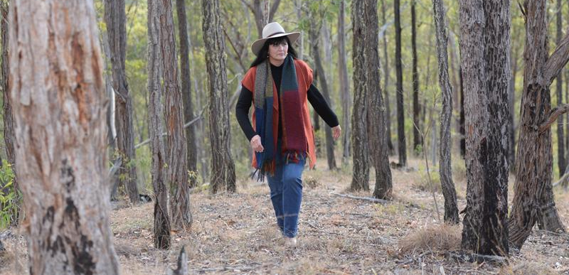 Growing concern: Bronwyn Petrie, who farms at Tenterfield in the Northern Tablelands. Photo credit: Fairfax Media
“So many people had permits from the Soil Conservation Service that allowed them to either clear or thin trees on land over 18 degrees,” Bronwyn says, referring to the environmental consulting and soil conservation business which as of September 2017 was transferred to the LLS. She believes that, rather than being restricted, tree thinning should be mandatory on those slopes because, where trees are too thick there is bare soil underneath, and rain washes the topsoil down.
“Not only is productive land at risk, it is not allowing farmers to rehabilitate the land that has had too many trees come up. It was an issue raised repeatedly with the DPI [Department of Primary Industries] in the negotiations over two years, and we were told it would be fixed. It wasn’t fixed, other than allowing thinning along fences and roads. Big whoop.”
Bronwyn says she feels personally betrayed by the change, particularly as she sees no logic in the decision: “We have no argument with them restricting land over 30 degrees and that would then keep us consistent with the Private Native Forestry Code and State Forestry, which allows timber harvesting up to, and including, 30 degrees.
“They can have machines on those slopes dragging the trees down, but if you’re trying to just control your regrowth on your property you can’t,” she says. “It is just so wrong.”